Despite the scorching temperatures, cyclists are pulling up their lycra bibs and heading up Salt Lake City’s canyons this summer. It’s an intimidating sport for those of us who prefer to slowly cruise around town. But Desmond Jensen, the road captain for the Bonneville Cycling Club, has some advice for novice and experienced cyclists alike.
Beginner and intermediate-friendly rides
Salt Lake City’s big mountains are part of its appeal but sometimes a 5,000-foot elevation climb just sounds like too much.
Those looking for a nice flat recreational ride can go along a frontage road to the Salt Lake Marina.
“That’s about as flat as it gets,” Jensen said.
For a bit of a climb, Jensen recommends one of Salt Lake’s most popular rides: Emigration Canyon. It’s a little less than 8 miles from top to bottom and has a 1,297-foot elevation gain. There’s a wide shoulder and lots of fellow cyclists. Plus, if you do get tired, it’s all downhill on the way back. And riders can stop at Emigration Brewing or Ruth’s Diner on the way home.
Rose Canyon in Herriman is another option and “probably as easy as it gets,” Jensen said.

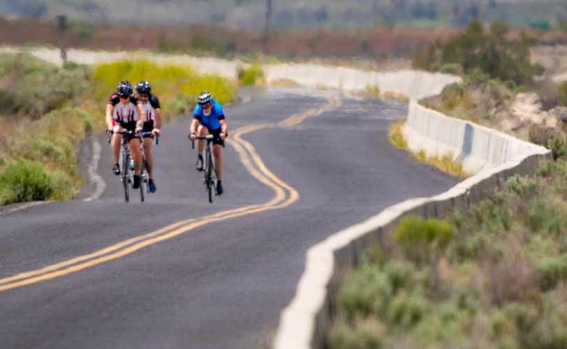
(Francisco Kjolseth | The Salt Lake Tribune) As the mercury rises, heat waves obscure cyclists along the North Temple frontage road near the Great Salt Lake on Thursday, May 26, 2022.
Challenging rides:
Mill Creek Canyon
Distance: 9 miles
Elevation Gain: 2,672 feet
Mill Creek Canyon is one of Jensen’s favorite rides because it’s well shaded (for the most part).
“In the summertime, it is probably the most glorious canyon, in my opinion,” Jensen said.
If you decide to start part way up or ride the trails, there’s a fee for driving up — $5.00 for the day, $3.00 if you’re a senior or $50.00 annually, $30.00 for an annual senior pass.
There are plans to widen this road starting next summer, so head up now because the upper portion of the road will be restricted for the 2-year construction period.
Erin Alberty|The Salt Lake Tribune A cyclist rides under a tapestry of fall color in Mill Creek Canyon, Salt Lake County.
Big Cottonwood Canyon
Distance: 16.9 miles
Elevation Gain: 4,992 feet
The traffic up the cottonwoods is heavy and cars tend to go fast around blind turns. The climb up to Guardsman is brutal. It could be a nice ride for those who say they “like type 2 fun.”
Little Cottonwood Canyon
Distance: 10.5 miles
Elevation Gain: 3,998 feet
Little Cottonwood Canyon is considered more difficult “because you don’t have a lull in it,” Jensen said. “It’s climbing pretty much all the way up.”
But the views are iconic and cooler temperatures prevail up in the Aspen forests.
Parts of Little Cottonwood Canyon road could close this summer as the Utah Department of Transportation installs new remote avalanche control systems.
(Francisco Kjolseth | The Salt Lake Tribune) A cyclist heads down Little Cottonwood Canyon on Saturday, August 21, 2021.
City Creek Canyon
Distance: 5.7 miles
Elevation Gain: 1,307 feet
This is a short, steep ride and also parts of it are currently closed due to construction on a water treatment plant.
(Chris Samuels | The Salt Lake Tribune) People recreate in City Creek Canyon in Salt Lake City, Friday, Oct. 20, 2023.
Butterfield Canyon
Distance: 6.6 miles
Elevation Gain: 2,213 feet
It’s in the mysterious Oquirrh Mountains and the pictures on Strava look breathtaking. One Salt Lake Tribune reader wrote in to give us the scoop:
“Never much traffic, the lower portion is wide and nicely paved. It gets steeper as you go up, very steep in a few spots, and the road gets really rough.”
Nick told The Tribune that while the Kennecott mine is visible the whole time “it doesn’t really detract from the scenery.”
Al Hartmann | The Salt Lake Tribune Butterfield Canyon Road winds its way up the lower end of Butterfield Canyon at about 13100 South and 9000 West. It's closed in the winter. The right side of the road is Kennecott property and left side is BLM land.
Safety first
Before heading, Jensen recommended making sure that your tires and brakes are in good working order.
“Pace yourself going up,” Jensen said, “and don’t be a daredevil going down because you don’t get paid to ride that bike.”


