

This article is part of The Salt Lake Tribune’s New to Utah series. For more articles on Utah’s food, culture, history, outdoors and more, sign up for the newsletter at https://www.sltrib.com/new-to-utah/.
When trying to understand Utah, there are multiple ways of looking at it. The history of Utah goes back further than just its founding in 1896. Indigenous tribes have called this area home for centuries. Millions of years before that, dinosaurs roamed the area. Utah is inextricably linked to the LDS Church and the Mormon pioneers who entered the Salt Lake Valley in 1847. Utah’s unique climate and topography play a role in how it is viewed.
Here are five maps and some history to better understand the Beehive State, both its past, present and future.
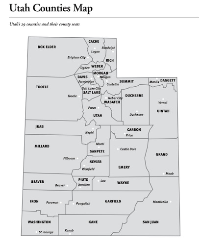
(Utah Education Network) Map of the counties and county seats of Utah.
Utah counties map
Utah has 29 counties, each with its own county seat. The county with the largest population is unsurprisingly Salt Lake County, which is home to the capital Salt Lake City. There are roughly 1.186 million people who live in Salt Lake County, or about a third of Utah’s population (3.380 million). Daggett County, located in the upper east corner of the state, has the smallest population with only 1,014 people.
Here are some quick facts about some of our counties:
Box Elder County is located in the upper west corner of the state and is home to Promontory Point. On May 10, 1869, the Central Pacific Railroad from the west joined with the Union Pacific Railroad from the east to make the transcontinental railroad that spanned the entire country.
Davis County is the smallest of Utah’s counties when it comes to land size, but has the third largest population. During World War II, Hill Field (now known as Hill Air Force Base) was a vital maintenance and supply base to the U.S. military, with round-the-clock operations to support the war effort.
Grand County was considered a typical “wild west” area in the 1800s, with hideouts for many outlaw gangs, the most famous being Butch Cassidy and the Wild Bunch. Moab is now known as the epicenter of Utah outdoor activities, including camping, hiking, ATVs and dirtbiking.

Subscribe To New To Utah Newsletter
Get the latest news by subscribing to our New To Utah newsletter. Enter your email below to receive more stories like these right to your inbox.
While the capital is now in Salt Lake City, it originally was in Fillmore in Millard County. They were both named after President Millard Fillmore. It was selected to be the capital because it was located in the geographic center of the Utah Territory (the predecessor of the state of Utah).
Many movies have been filmed in Kane County over the years due to its scenic red rocks. The area was so popular in the 1930s-60s, that the city of Kanab is referred to as “Little Hollywood.” Some of the movies filmed in Kane County include Stagecoach (1939), The Rainmaker (1956), Point Break (1991), Mission Impossible II (2000) and Planet of the Apes (2001).
It is mostly well known that Salt Lake County is where The Church of Jesus Christ of Latter-day Saints has its headquarters. Utah was primarily settled by Mormon pioneers and the LDS Church remains Utah’s predominant religion (though membership numbers have diminished over the years in Salt Lake County).
In Tooele County, there is a barren area that is a remnant of the Pleistocene Lake Bonneville. Called the Bonneville Salt Flats, the roughly 12 miles by 5 miles area has a crust of salt that is 5 feet thick at the center and less than one inch thick at the edges. The area is extremely flat and smooth, making it the perfect place for motor speed trials. Vehicles have reached upwards of 600 mph on the flats.
Population distribution
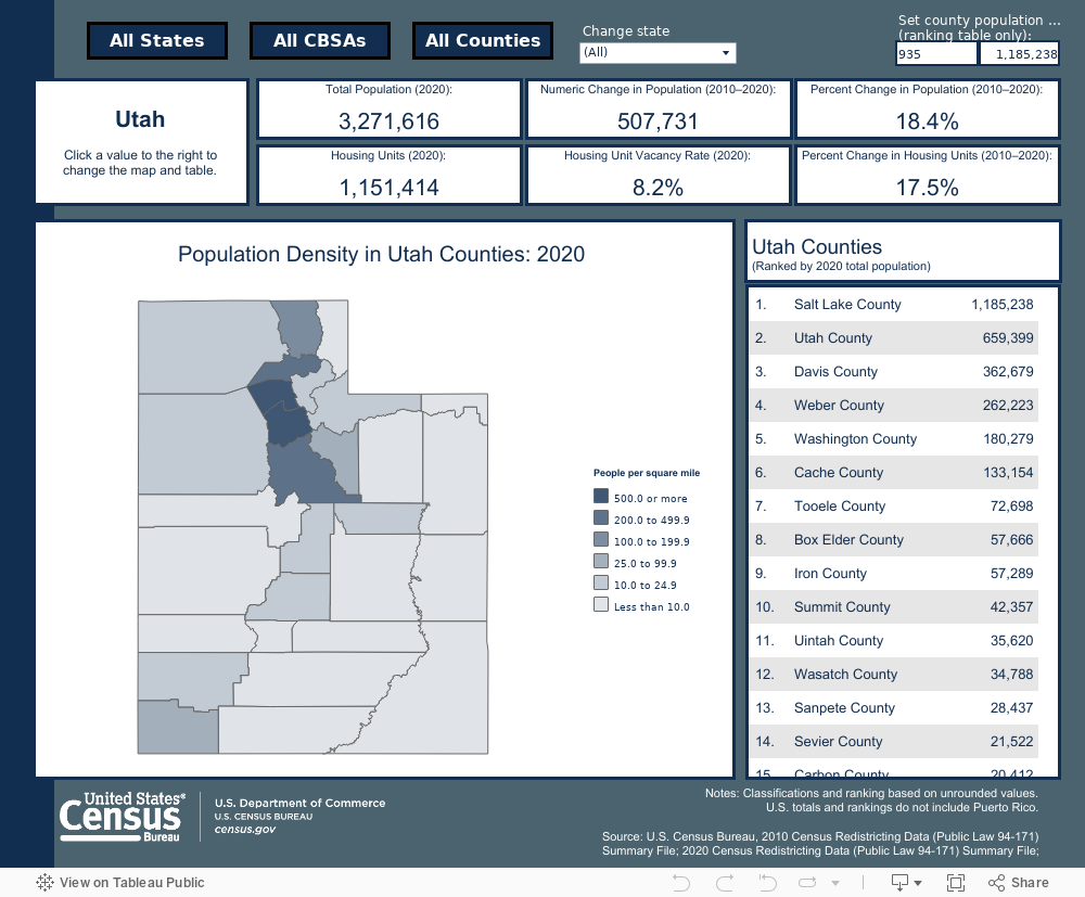
Utah is home to about 3.380 million people, according to the latest Census figures. Over 75% of Utah’s population lives in the Wasatch Front, a long and narrow metropolitan area that runs along the Wasatch Mountains going north to south.The area stretches from Logan in the north to Santaquin in the south, a distance of 120 miles, though most live in the area between Ogden and Provo (80 miles). The four counties that make up the Wasatch Front are Salt Lake, Utah, Davis, Weber and Cache, which have a total population of around 2.6 million people based on the 2020 Census data.
The counties with the smallest populations are Daggett (1,014 people), Piute (1,487 people) and Rich (2,628 people).
By far, Utahns are predominately white, accounting for 90.3% of the population. The biggest minority population is Hispanic or Latino, with 14.8% of the population.
The Church of Jesus Christ of Latter-day Saints remains the predominant religion of Utahns with 55%. The next largest grouping is the “unaffiliated” group, or people who don’t ascribe to any religion with 22%.
Congressional Districts map
Aside from our two Senators, Utah has four members in the House of Representatives. The districts where they serve were redrawn in 2021, which caused a lot of controversy.
An independent redistricting commission was called in 2018 to draw up new maps of how the state would be divided among its congressional representatives. Utah lawmakers took those maps into consideration, but ultimately created their own maps. The biggest area of contention was Salt Lake County, the bluest county in the red state of Utah, being divided into the four districts. A lawsuit was filed against the redistricting, saying it amounted to gerrymandering and would make it near impossible for a Democratic nominee to win election.
To find out who your House of Representative delegate is, visit https://www.house.gov/representatives/find-your-representative
(Utah Division of Indian Affairs) Map of the Indigenous tribes of Utah.
Five Indigenous tribes map
When Utah updated its state flag, it included a five pointed star meant to represent the five historic Indigenous tribes that continue to live in Utah. These include the Ute, Diné (Navajo), Paiute, Goshute and Shosone. While their historic tribal lands encompassed the entire state, current reservation boundaries for the tribal nations take up a fraction of what used to be their lands. Utah is home to approximately 60,000 Native Americans from over 50 Tribal Nations (eight of which are federally recognized).
The Northwestern Shoshone (pronounced shuh-show-nee) is based in northern Utah and southern Idaho. Related to the Paiute, Bannock and Ute people, they all call themselves Newe or Neme, meaning “The People.” Before contact with Europeans, they formed small extended-family groupings and traveled extensively as semi-nomadic hunter/gatherers. The Shoshone were once called “So-so-goi,” which means “those who travel on foot.”
The Goshute (pronounced go-shoots) are part of a larger Shoshonean-speaking group. The name Goshute derived from the native word “kuisutta” meaning ashes, desert or dry earth. While the Goshute have been living in the Utah area for over 1,000 years, they were living in the desert regions to the southwest of the Great Salt Lake when the Mormon pioneers entered the Salt Lake Valley.
The Northern and Southern Ute (pronounced yoot) are thought to have arrived in the Great Basin territory around 500 A.D., absorbing the preexisting Fremont people. They became the largest group of people in the area over the next 500 years, stretching from Utah, Colorado, Wyoming and New Mexico. They acquired horses around 1637, making them the first Native Americans to introduce horses into their culture.
The Paiute (pronounced pie-yoot) have their ancestral lands anchored in southern Utah, southeastern California, northern Arizona and southern Nevada. Scholars mostly agree that the Paiutes entered Utah about 1100-1200 A.D. The first contact between Utah Paiutes and Europeans occurred in 1776 when a 10-man exploration team lead by two Franciscan priests named Father Francisco Atanasio Domínguez and Father Silvestre Vélez de Escalante encountered Paiute women gathering seeds (That exploration team became known as the Dominguez and Escalante Expedition). During the 1940s to 1960s, the Paiute Indian Tribe was targeted for termination by the federal government as part of the Indian termination policy. This ended not only the U.S. government’s recognition of tribal governments and tribal lands, it terminated federal support of most health care, education programs, utility services and police/fire departments on tribal reservations.
The Navajo (pronounced na-vuh-ho) people traditionally refer to themselves as Diné, (pronounced din-neh) meaning “the people.” While archeological evidence doesn’t reveal when the Diné first came to the Four Corners area, it is thought it was between 200 - 1300 A.D., with the Navajo mixing with the ancient Anasazi and Pueblo people. The Navajo played a major role in World War II as code talkers. Around 400 Navajo Marines would send and receive messages in their native language, a language that baffled the Japanese. They developed a dictionary for military terms that had to be memorized during training. Navajos could encode, transmit and decode a three-line message in 20 seconds, something that took machines 30 minutes. The Navajo code talkers were honored for their contributions to the war effort in 1992.
Utah also carries a history of atrocities against its native people. Aside from forcing Indigenous people off their ancestral lands, eight native boarding schools and dormitories were built in Utah. These schools took native children from their parents and homes and forced them to live in boarding schools where their hair was cut, they were forced to wear uniforms and forbidden to speak their native language. The idea behind these schools, which existed all over the U.S., was to assimilate native children to the “white” culture. Richard Henry Pratt, who opened a boarding school in 1879 in Pennsylvania, famously said the schools would “kill the Indian in him and save the man.”
Untold horrors took place at these schools, including physical and sexual abuse, malnutrition, forced labor and epidemics. There is no official total how many children died at these schools. Unmarked graves continue to be found at the old sites.
(Freeworldmaps.net) Map of Utah mountains. Link: https://www.freeworldmaps.net/united-states/utah/utah-mountains-map.jpg
Topographical map
When it comes to the topography of Utah, you’ll be hard pressed to find a state with more variety. We have mountains, deserts, lakes and red rocks, as well as things unique just to Utah.
There are dozens of mountain ranges within Utah. In northern Utah, one of the most prominent is the Wasatch Mountain Range (pronounced wah-satch), which is part of the western edge of the greater Rocky Mountains. The name comes from the Ute tribe and means “mountain pass” or “low pass over high range.” It consists of about 160 miles from the Utah/Idaho border to central Utah and its canyons provide critical watersheds for cities’ drinking water. Nearly 85% of the state’s residents live within 15 miles of the Wasatch Mountains in what is called the Wasatch Front. Its highest peak is Mount Nebo at just under 12,000 ft elevation. It was also host to many of the skiing events during the 2002 Olympics and has numerous ski resorts up and down its range.
The Uinta Mountains (pronounced you-in-tah) are one of the few mountain ranges in North America that run east to west and are the highest range in the contiguous United States that do so. Located in the eastern part of the state, it has the highest point in Utah at King’s Peak (13,528 ft). Scattered throughout the mountain range are over 1,000 natural lakes, half of which support game fish. There are over 400 miles of streams. In contrast to the deserts surrounding the range, the area gets huge amounts of snow and temperatures above 10,000 feet rarely get above 80 degrees.
In southern Utah, the La Sal Mountains rise over 8,500 feet and offer impressive views of its neighboring redrock Canyonlands and Arches National Parks. Its highest point is Mount Peale at 12,721 ft. The range mostly consists of three cluster peaks with passes in between.
Traveling down from the mountains in southern Utah, you’ll encounter stunning redrock views. While it’s called “redrock,” the sandstone can be red, yellow, brown and orange. Aside from their striking color is their unique formations called hoodoos. These mushroom-shaped rocks are caused by erosion of the relatively soft sandstone. The most impressive of these can be found in Bryce Canyon National Park and in Goblin Valley State Park, which features some of the largest hoodoos in the world.
Another unique geological feature to result from the prevalent sandstone are naturally occurring arches in southern Utah. Also created by erosion, the most famous of these is Delicate Arch in Arches National Park. The 52-foot freestanding arch is the most widely recognized landmark in the state and is depicted on Utah license plates. The trail leading up to the arch is one of the most popular in the national park.
Combining the beauty of the redrock with the blues of lakes is Lake Powell in southern Utah. Officially called the Glen Canyon National Recreation Area, Lake Powell is an artificial reservoir on the Colorado River in Utah and Arizona. It is the second largest artificial reservoir behind Lake Mead. A dam was completed in 1963 and the Colorado River began filling up Glen Canyon, a feat that took 17 years to reach capacity at 3,700 feet. The dam creates hydroelectric power for surrounding areas, while the water provides recreation. In 1983, the dam nearly failed due to so much water flooding down to the lake due to record breaking snow falls in the areas that feed into the Colorado River. However, starting in 2000, a megadrought has caused the lake levels to drop dramatically.


