


This is an archived article that was published on sltrib.com in 2013, and information in the article may be outdated. It is provided only for personal research purposes and may not be reprinted.
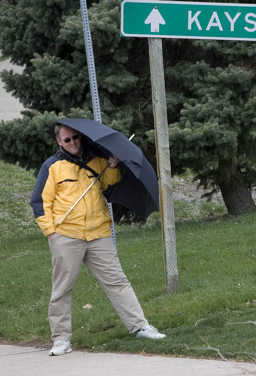
Tuesday dawned windy and cold throughout Utah, but gusts near hurricane force along mountain ridge tops were expected to diminish to a more spring-like breeze by Wednesday.
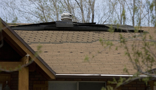
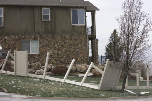
Winds topping 60 mph whipped heavy snowfall in some mountain locations, prompting the closure Tuesday of all schools in northern Utah's Rich County. In Davis and Weber counties, the high winds were blamed for power outages as electrical lines were knocked down by snapped tree limbs and a number of transformers were overwhelmed.
The National Weather Service reported via Twitter about 9:20 a.m. that Centerville had winds gusting to 75 mph.
Rocky Mountain Power reported more than 5,100 customers awoke without electricity in Ogden and neighboring South Ogden. Crews had restored service by 8 a.m. Tuesday. Wind-related outages in the towns of Clinton and Sunset also were reported overnight, though services there had been restored by 5:30 a.m. to hundreds of affected homes and businesses.
Another outage, this one in northeast Salt Lake City, affected 1,400 customers, but Rocky Mountain Power said the electrical service interruption was due not to weather but a traffic accident. Service had been largely restored to the area by 8:45 a.m.
Stretches of Interstates 15 and 215 became commuter headaches early Tuesday as well, with icy road surfaces bringing traffic to a crawl. Both Big and Little Cottonwood canyons were briefly restricted to chained or four-wheel drive vehicles. Interstate 80 from Evanston to Lyman, Wyo., was closed from mid- to late-morning Tuesday due to blowing snow.
The National Weather Service let a Winter Weather Advisory for a stretch of the Wasatch Mountains from Logan south through Ogden, Salt Lake City and Provo to Nephi and Manti and extending to Duchesne, expire at noon Tuesday. That area received 7-15 inches of new snow in the mountains with winds near 60 mph reducing visibility in the region's passes.
A Winter Storm Warning was being left in place until 9 p.m. Tuesday for the Wasatch Plateau, the southwest desert and a pocket of southeastern Utah including Monticello. Forecasters said 1-2 feet of new snow fell in the region's mountains and high deserts, again with gusts up to 60 mph rendering travel treacherous.
The Canyons reported 16 inches as of Tuesday morning, with Alta at 14 inches, and Big Cottonwood Spruces and Brighton at 12 inches each. Solitude came in at 11 inches, Deer Valley reported 21 inches and Park City's Summit station received 18 inches.
Wind warnings and advisories also were to run through 9 p.m. Tuesday. A High Wind Warning was in place for the northwest desert and the Salt Lake and Tooele valleys with wind speeds of 30-40 mph and gusts topping 60 mph.
A Wind Advisory, for winds in the 20-30 mph range and gusts near 50 mph, was in place for southeastern Utah.
The new snowfall prompted the Utah Avalanche Center to elevate its risk assessments for dangerous snow slides, with the Salt Lake City, Ogden and Provo mountains rated at "moderate" and the Logan mountains and the Uintas graded "considerable."
The Utah Division of Air Quality rated the entire state as "Green," or healthy for breathability.
Overnight temperatures throughout the state retreated to winter-like readings. Salt Lake City's high on Wednesday was pegged at 53, following an overnight low of 31 and a forecast Tuesday high of only 45 degrees. Ogden looked for 31, 53 and 44 degrees, respectively; Provo 29, 53 and 42; Logan 26, 53 and 43; Wendover 34, 61 and 49; Duchesne 21, 48 and 32; Cedar City 20, 52 and 43; St. George 38, 69 and 61; and Moab 25, 50 and 39 degrees.
Twitter: @remims Travel forecast for Tuesday •
Impact: Crosswind gusts:
Crosswind gusts of 50-55+ mph will impact I-15/US-89 between Weber Canyon and Woods Cross into Tuesday afternoon
Crosswind gusts of 50-55+ mph will impact US-6/191 from Helper to Green River before 5 P.M. Tuesday.
Crosswind gusts of 50-55+ mph will impact US-40 east of Vernal through 5 P.M. Tuesday.
Crosswind gusts of 45+ mph will impact I-80 west of Salt Lake City through Tuesday afternoon.
Crosswind gusts of 45+ mph will impact SR-30 west of I-84 through Tuesday morning.
Impact: Road slush/snow:
I-80 over Parleys Summit (east of Salt Lake City) will see periods of road slush under heavier snow through Tuesday morning.
Most northern valley routes will run wet under any showers Monday afternoon and Tuesday morning. Road snow/slush will impact the Cache Valley Tuesday morning.
Periods of road snow will impact I-15 between the Dog Valley/Cove Fort/I-70 Junction through 11 A.M. Tuesday. Road snow will be heavy at times near the Cove Fort area through Tuesday morning. This areas will mostly run wet under any remaining snow showers after noon Tuesday.
Periods of road snow will impact I-70 over Clear Creek Summit (just east of the I-15 Jct.) and over Ivie Creek Summit (east of Richfield) through 11 A.M. Tuesday. Road snow will be heavy at times through Tuesday morning with the heaviest amounts falling over Clear Creek Summit. These areas will mostly run wet under any remaining snow showers after noon Tuesday, but brief road slush will be a threat under any snow showers Tuesday afternoon.
SR-44 (south of Manila) and US-191 summits north of Vernal will see road snow through Tuesday afternoon. Road snow will be heavy at times through noon Tuesday. Significantly impaired travel is expected for these routes Tuesday morning.
Source: Utah Department of Transportation Storm closes Wyoming highways, delays Denver flights
A storm that toppled trees, whipped up blinding dust storms and may have spawned some tornadoes closed highways in Wyoming Tuesday and was slowing flights at Denver International Airport.
In Wyoming, a 100-mile stretch of Interstate 25 between Cheyenne and Douglas was closed as well as a 125-mile section of I-80 between Laramie and Rawlins. More than a foot of snow had fallen as of midmorning in Lander. In Pine Bluffs, near the Nebraska border, wind has created 1- to 2- foot drifts out of the snow that has fallen there.
Wind gusts up to 71 mph damaged a marina and windows in Sweetwater County.
The storm has so far proved less potent than originally predicted in Colorado because the cold front lingered in Wyoming.
Up to around 10 inches of snow had fallen in Colorado's mountains by dawn Tuesday. Another 5 to 10 inches was possible in some locations but final snowfall amounts would vary quite a bit, National Weather Service forecaster Jim Daniels said.
Up to a foot had been in expected in Denver but forecasters are now calling for around 5 inches.
The storm has canceled 465 flights at Denver International Airport and deicing was causing departing flights to be delayed by as much as a half hour.
Blizzard warnings are also in effect from south of Denver to the New Mexico line and in northwestern Colorado. Winds gusting up to 50 mph were expected there.
As the storm moved in Monday night, spotters reported two tornadoes near Akron in eastern Colorado.
Northern California was first to feel the lashing blasts of the storm Monday, which spread to the Sacramento and San Joaquin valleys.
At least a dozen trees came down in San Francisco, police officer John Tozzini told KGO-TV, which reported that more than 20,000 utility customers lost power in the region. A swath of outages occurred across the Sacramento Municipal Utility District, the Sacramento Bee reported.
A tree smashed into a Sacramento home where four friends were playing bridge, but they didn't stop playing their game Monday, according to KCRA.
Gusts topped 80 mph at some places in Southern California. The blustery system was being fueled by a cold front.
"It's just a cold, really strong upper low," said Carol Smith, a meteorologist with the National Weather Service in Oxnard, Calif.
Whitecaps flecked the Pacific Ocean along the California coast, where gale warnings and small craft advisories were posted. Recreational boaters were warned to stay in port. Wind-driven swells slapped over the tops of breakwaters and turned waves into a churning froth under piers at points such as Redondo Beach and Manhattan Beach on the Los Angeles County coast.
The wind turned small wildfires into big problems in some areas, including a blaze in Fillmore about 50 miles northwest of Los Angeles that burned two homes and forced the evacuation of 84 homes.
Blowing dust forced the closure of state Route 14 in the high desert Antelope Valley north of Los Angeles due to low visibility. Officer Michael Farrell said motorists who stopped on the road were hit from behind by other cars, but no major injuries were reported.
The power went out for more than 13,000 Southern Californians because of the winds and the weather.
The rush of air had an upside: California's main power grid manager, the Independent System Operator, reported that turbines spinning within the ISO grid produced a record of 4,196 megawatts Sunday. The previous record was 3,944 megawatts on March 3.
In Arizona, gusty winds produced by a cold front enveloped Phoenix in a dusty haze and closed 34 miles of Interstate 40 in the northern part of the state for several hours Monday. At least four people were injured in a pileup when two semi-trucks jackknifed in a dust storm on I-10 in southern Arizona. The injuries were not life-threatening.
The Associated Press