

This is an archived article that was published on sltrib.com in 2012, and information in the article may be outdated. It is provided only for personal research purposes and may not be reprinted.
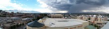
Afternoon thunderstorms dumped rain Monday as wind gusts up to 60 mph ripped through the state.
Some flooding was reported in Zion National Park about 5 p.m. as early afternoon rainstorms trickled into Zion Canyon, said National Weather Service forecaster Mark Struthwolf.
"Rangers said there were waterfalls larger than anything they'd seen in the last few years," Struthwolf said.
The Fort Pierce Wash, which flows into St. George, went from a dry creek bed to a river eight feet deep over the course of the afternoon, Struthwolf said.
Later in the day, thunderstorms brought torrents of rain to northern Utah, with nearly an inch falling between 6 p.m. and 7 p.m. in Layton.
As of 8 p.m., more than an inch of rain had fallen at several sites statewide, including Magna, the Utah Test Range, west of the Great Salt Lake, the San Rafael Swell and Brimstone Reservoir of southwest Utah.
Tuesday was expected to bring mostly sunny skies and higher temperatures statewide, with a high of 89 in Salt Lake City and a high of 95 in St. George.
A chance of showers remained in the Uinta Mountains and the central Wasatch, Struthworth said.
Occasional showers during the weekend provided aid to firefighters battling wildfires, but also caused flooding in St. George.